
Maintenance
The shared facilities of the Arbors are maintained mainly by volunteers. If you see an issue (light out, broken playground equipment, gate malfunction, etc.), please click here to generate a request on TownSq app or go to the app directly (select "Maintenance" from the pull down menu).
Hydrants and Light Pole Map
The map below shows the fire hydrants and light pole numbers. You can use the light pole numbers to report lamps that are not working to this site. Type the pole number into the field labeled "closest pole".
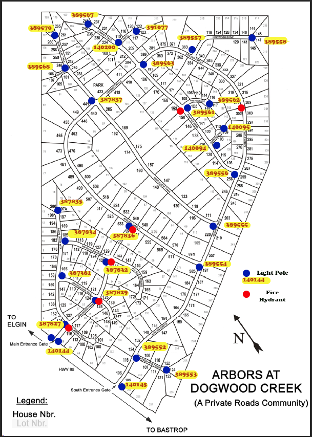
The Arbors subdivision has a mixture of different fire hydrants, painted and color coded as to their capabilities:
Red: These hydrants are capable of providing the high pressure that fire trucks use to pump water directly from the hydrant onto a fire.
Black: These hydrants are not designed to provide high pressure, but are used to fill fire department water pumpers, which do have the capability to provide the pressure to pump water onto a fire..
Stand Pipes: 2" lines used to fill fire truck water pumpers.
Note: The EVFD has the location of every hydrant and pipe stand in our community.
Roads
The Arbors at Dogwood Creek is a private road community and our roads DO NOT belong, nor are the responsibility of Bastrop County. All maintenance and up-keep is the joint responsibility of Arbors property owners. For that reason it is incumbent on all homeowners to be vigilant for those who disrespect our roads through injurious actions: littering, digging into the road bed, damaging asphalt with misuse of heavy equipment, negligent fuel leaks, concrete spills, dumpster dragging, etc.
The Arbors can rightfully boast to having some of the best roads in Bastrop county. Please help keep them that way...
Proper management of road-edge vegetation is critical to maintaining our roads. Uncontrolled vegetation can cause damage to to road edges when roots burrow under the asphalt and allow water to enter. vegetation can also loosen the hardened roadbed aggregate, enabling erosion effects.
The overwhelming majority of the roadside vegetation is controlled by mechanical means, ie, mowing. However, in some instances, vegetation persistence or equipment limitations render conventional cutting methods ineffective or impossible. For these situations, road managers such as TxDot typically apply herbicides.
The Maintenance Committee has researched several options for controlling road-edge vegetation with the goal to be as environmentally unobtrusive as possible, while still getting the job done. Any herbicide spraying is done in accordance to accepted road management methodology.
Easements
Texas Real Estate Law defines an easement as a right, privilege, or advantage in real property, existing distinct from the ownership of the land. Easements consist of an interest (or estate) in real property that does not constitute full ownership.
Most commonly, an easement entails the right of a person (or the public) to use the land of another in a certain manner. The following language appears in Sect III of the property purchase agreements with Sabine Investments (the developer):
DEED: "Seller's Warrantee Deed shall convey good and indefeasible title subject only to the following:
1) Any and all easements, covenants, right-of-way, restrictions, and reservations which may appear of record in the office of the County Clerk of the County in which any or all of the Property is located.
2) Any portion of the Property lying within the boundary of a road or roadway.
3) Any visible or apparent easements or right-of-way across or upon the property.
4) Any and all reservations and restrictions that apply to the title to the Property, including utility and flowage easements.
Right of Way and Erosion Control
From the Arbors subdivision Plats filed with Bastrop County: "except as noted, all roads have a 60' r.o.w. All cul-de-sacs have a 60' radius." (there are no exceptions noted on the plats)
Why do we work so hard to control Right of Way (r.o.w.) erosion? It's not just for esthetics! It's because the Arbors has very good roads, better than most in Bastrop county, and we must protect the road bed which is part of it. And that means keeping the ROW from eroding toward the street.
Erosion starts when vegetation is killed or removed in the right-of-way; rain washes the sand away from the road bed and eventually holes develop under the road. Then repairs become very costly.
Better to control the erosion before it starts!!
* the 60 FT RIGHT-OF-WAY is measured from lot survey rod, over the road, directly to the lot survey rod on the opposite side. In theory, 17.5 feet on each side of the road are responsibility of the AIA. Because road width may vary, For maintenances purposes, 15 feet measured inward from the edge of the road will be mowed by the Maintenance committee.
* Water, cable, and telephone utilities that service our homes are buried in the P.U.E. (Public Utility Easement) granted by the developer. These are often in the middle of the R.O.W. and can be impacted by digging or vehicles that get stuck in the R.O.W. sand.
* R.O.W maintenance, mowing, and road-bed weed spraying are the responsibility of the AIA and not the individual property owner. Please do not place any type of obstruction (flag poles, waste receptacles, etc) or landscaping (flower beds, rock gardens, etc) on the Arbors R.O.W. as these will interfere with mowing and maintenance activities.
*Individual lot owners pay taxes only on their property...contained within the marker rods as noted on their lot survey.
*Individual lot owners do not pay direct property taxes on the 60' R.O.W. which has been reserved by the developer for the AIA.
Lower Colorado River Authority (LCRA)
The LCRA is a Texas conservation and reclamation district operating with no taxing authority. In addition to other conservation activities, it operates more than 3,300 miles of transmission lines statewide and provides wholesale electricity to our Bluebonnet electric Coop.
LCRA POWER LINES traverse the Arbors subdivision in some locations. A portion of the lots across which this utility easement traverses is reserved for LCRA use.
While property owners do pay COUNTY taxes on the portion of the easement that encompass their individual lots, and are allowed free access to the property therein, no structures or barriers may be built on this easement which would prevent clear access by LCRA personnel.
* Responsibility for up-keep of these easements belongs to the LCRA.